On 06 December 2022, the European Union approved the EU Deforestation Regulation, or EUDR, which is a bold and much-needed step in curbing deforestation, forest degradation, and general environmental and human rights infractions in the production and consumption of certain imported and exported goods and commodities within the European Union. These include palm oil, cattle, timber, coffee, cocoa, rubber and soy. Derived products also included in the Regulation are chocolate, furniture, printed paper, and certain palm-oil-based products among others. In this article we touch on how Swift Geospatial can assist in your EUDR compliance through earth observation monitoring solutions.
This Regulation aims to promote deforestation-free supply chains, according to European Union Law, which will contribute to the reduction of carbon emissions by at least 32 metric tons a year. In euro value, reducing these emissions would equate to a saving of at least €3.2 billion that could be funnelled back into reforestation and climate change initiatives.
For Europeans, this Regulation also guarantees them peace of mind in knowing that the products they buy do not contribute to deforestation. As Frans Timmersmans, Executive Vice-President for the European Green Deal, said: “Our deforestation regulation answers citizens’ calls to minimize the European contribution to deforestation and to promote sustainable consumption.”
What are the top drivers of deforestation and how can EUDR help?
The London School of Economics and Political Science reported the annual rate of deforestation as some 10 million hectares per year between 2015 and 2020, and according to KPMG, imports to the EU are one of the biggest drivers of global deforestation.
So, what are the top drivers of deforestation and how can the Regulation limit their impact?
The United Nations Environment Programme lists agricultural expansion as one of the top drivers of deforestation, forest degradation and biodiversity loss, while the Union of Concerned Scientists of USA agrees, going into more detail to list large-scale soybean production, pasture expansion for cattle production, palm oil plantations and logging as specific activities.
A summary from the European Commission also lists coffee and cocoa as top deforestation drivers in the European Union.
The EUDR lists seven specific commodities and their derivatives as most harmful in a deforestation context, and six of the seven above are on that list. The seventh is rubber; forested areas are often cleared to make room for growing rubber trees says the WWF, and the same is true of most of the commodities listed here.
Under EUDR, companies across the supply chain will need to confirm that they meet EU regulations before any products or their derivatives are placed on the EU market. This means providing certain geolocation and traceability records to Regulation Member State authorities for vetting, as well as sharing the satellite monitoring tools and field audit techniques used along the production journey to ensure compliance to ‘deforestation-free’. Benchmarks will also be put in place by the European Commission to better gauge deforestation risk across these top drivers as well as per country.
Companies across the supply chain have until 30 December 2024 to comply with key articles within the Regulation. From this date, it will be prohibited to place commodities and derived products on the EU market or export them from the EU unless the following criteria are met says global law firm White & Case:
- commodities and products are classified as deforestation-free;
- they were produced in accordance with the relevant legislation of the country of production; and
- they are covered by a due diligence statement indicating no more than a negligible risk of non-compliance; in other words, the risk of non-compliance is small.
Small businesses and micro enterprises have until 30 June 2025 to comply to EUDR.
Sustainable forest management is crucial in preserving both the biodiversity and productivity potential of forests. Regulations such as EUDR are driving real change on the journey towards greater environmental, social and economic sustainability.
How can Swift Geospatial play a role in assisting your company’s compliance?
As a premier GIS and remote sensing solutions company that specialises in satellite imagery monitoring and change detection, we are well-versed in what legislative requirements impact our clients. One of these is the EU Deforestation Regulation (EUDR).
Swift Geospatial began constructing an EUDR monitoring solution for clients in 2021. This solution has been shaped by our clients’ feedback and expectations, and we’ve learned that no one size fits all. Each client requires their own set of inputs, monitoring frequency, and outputs. This is what Swift Geospatial provides our EUDR clients – a custom-built monitoring solution using the latest in polygon/field cleaning, verification, and imagery fusion to achieve the correct outputs to meet their needs.
Swift Geospatial EUDR monitoring solution features
- Customisability: Swift Geospatial works with each client to understand their specific needs and develop a solution that meets those needs.
- Accuracy: Swift Geospatial uses the latest in geospatial technologies to ensure accurate and reliable monitoring solutions..
- Comprehensiveness: Swift Geospatial’s monitoring solutions cover all aspects of EUDR compliance, from deforestation risk assessment to supply chain traceability.
- Flexibility: Swift Geospatial’s monitoring solutions can be scaled to meet the needs of businesses of all sizes.
Benefits of EUDR monitoring solutions
- Reduced risk: Swift Geospatial’s EUDR monitoring solutions help businesses reduce their risk of non-compliance with the EUDR.
- Increased transparency: We are able to provide businesses with a clear view of their supply chains, helping them identify and address deforestation risks.
- Improved sustainability: Our EUDR monitoring solutions help businesses to improve the sustainability of their operations by reducing their impact on forests.
- Risk assessment: High quality satellite imagery and other data is used to assess the risk or appearance of deforestation in the supply chain.
- Supply chain traceability: Swift Geospatial helps the coffee roaster to trace its coffee beans back to the farms where they were grown.
- Monitoring: Swift Geospatial monitors the supply chain for deforestation and other land use changes.


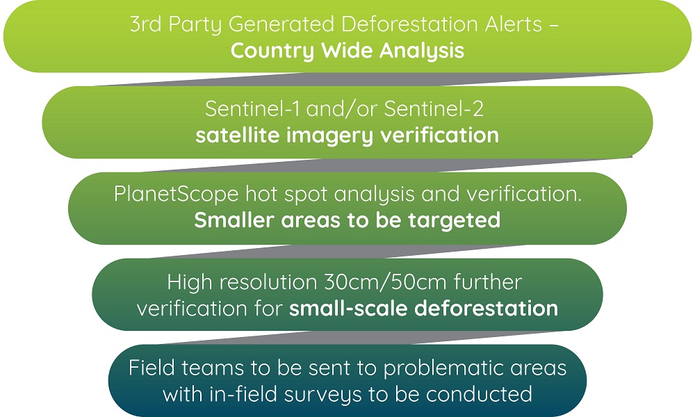
How it works – A 4 step process
- Data: Collect raw data imagery.
- Measure: Baseline collection– setting a base map to track and monitor changes.
- Verify: Ongoing monitoring– gather ongoing monitoring data.
- Report: Geospatial platform– present data and change detection through alerts and dashboard access.
The approach: Merging satellite imagery sets for optimal client results
With access to a variety of satellite imagery, each with their own capabilities and benefits, we can develop customised monitoring solutions based on a needs analysis for each individual project. Satellite imagery offers a distinct advantage by providing a unique perspective on your designated area. However, not all imagery holds the same level of usefulness. Low- and medium-resolution images allow observation of shapes, colours, and large environmental features like bodies of water or forests, while high spatial resolution unveils finer details such as vehicles, buildings, and even individuals, influencing important decision-making processes.
Some of the satellite imagery we have access to includes:
Free Data – Global Forest Watch
Global Forest Watch (GFW) is an online platform that provides near-real-time monitoring and analysis of global forests. It is an initiative that aims to promote transparency and accountability in the management of the world’s forests. GFW is a collaborative effort involving multiple organisations, including the World Resources Institute (WRI), Google, and various other partners.
Sentinel
Sentinel – 10m resolution Sentinel 1 & Sentinel 2 imagery verification
The multi-spectral data captured by the satellite encompasses 13 bands distributed across the visible, near-infrared, and shortwave infrared segments of the electromagnetic spectrum.
PlanetScope
PlanetScope 3m resolution – hotspot analysis and verification. (allows targeting of medium/smaller areas)
The PlanetScope satellite constellation consists of multiple launches (“flocks”) of Dove satellites. On-orbit capacity is constantly improving in capability and quantity, with technology improvements deployed at a rapid pace. Each satellite is a CubeSat 3U form factor (10 cm by 10 cm by 30 cm).
Maxar Technologies
50cm/30cm – higher-resolution satellite imagery allows for further verification of smaller areas
Maxar has 1.5 billion square kilometers of 30 cm class imagery collected—roughly 26 times Earth’s landmass. And 5,000 metro areas are covered in clear 30 cm class imagery, showing change over time in the globe’s most dynamic places.
Survey 123 – in-field verification.
ArcGIS Survey123 is a simple and intuitive form-centric data-gathering solution. Create, share and analyze surveys in just three easy steps.
The post How Can Swift Geospatial play a role in EUDR Compliance? appeared first on Swift Geospatial.


